Final Report and Brief
|
| |||||
Executive Summary
California has dramatically advanced its deployment of renewable energy technologies in an effort to reduce greenhouse gas emissions. Through the implementation of the 33% Renewable Portfolio Standard, the state government has spurred installation of utility scale (>20MW) renewables, and the largest growth is projected to come in the form of photovoltaic solar energy. Numerous projects have been slated for and constructed in the Mojave Desert, but issues with the Endangered Species Act and protracted stakeholder conflicts have significantly slowed construction in many instances, or led to unmitigated harm to wildlife in others. These conflicts and push backs haves led developers to seek opportunities in the San Joaquin Valley of California, an area where ESA issues are perceived to be less likely, and large tracts of previously developed land are available. The Smart from the Start Report, released by Defenders of Wildlife in 2012, states that there is a need for more decision support tools for smart growth initiatives, and this analysis is a critical first step.
The goal of the San Joaquin Valley (SJV) Landscape-Scale Planning for Solar Energy and Conservation analysis (WildLight) is to identify appropriate areas for photovoltaic solar development within the SJV. A secondary goal of the analysis is to identify high value conservation lands within the SJV that can targeted for protection and serve as mitigation areas for the construction of solar developments. Data from the major stakeholder groups in the region are used to generate a spatial model identifying and highlighting the most compatible areas for utility scale solar development; areas that satisfy the following criteria are highlighted as compatible for utility scale solar development:
· Low Agricultural Value
· Low Conservation Value
· High Solar Suitability
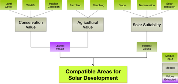
Figure E1. Conceptual map of the WildLight modeling approach with module inputs in green, modules representing the three stakeholder groups in gray, extracted values in purple (bottom left) and dark green (bottom right), and compatible areas for solar development in light green (bottom).
The WildLight Team worked with stakeholder groups, government agencies, and university researchers to generate and collect data as inputs to the Environmental Evaluation Modeling System, a spatial model developed by the Conservation Biology Institute. This model combines large spatial datasets to create an innovative and powerful decision support framework. This model allows for the integration and comparison of widely varying data types, producing a framework and outputs that are easily interpreted. Additionally, our model utilizes the best available data and is designed to be highly adaptable and capable of incorporating new data as it becomes available.

|
|
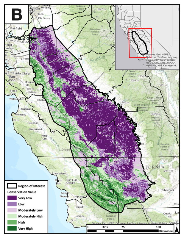
Figure E2. A) Environmental Evaluation Modeling System output of Compatible Areas for Solar Development. B) Environmental Evaluation Modeling System output for areas of High Conservation Value.
The final results of the WildLight analysis are presented in Figure E2. Dark green areas in Figure E2.A are compatible areas for solar energy development based on data representing conservation value, agriculture value, and solar suitability. Purple areas are less optimal for solar development due to high conservation value, high agricultural value, low solar suitability, or a combination of those three attributes. Similarly, dark green zones in Figure E2.B are high value conservation lands that should be targeted for conservation or mitigation areas by solar developers.
This analysis and model output identifies urban areas and the Westlands Water District as compatible areas within the SJV for utility-scale solar development. In total ~1 million acres were identified as highly compatible for utility-scale solar energy development in the SJV. Additionally, the results of the conservation value module identified ~200,000 acres as having high conservation value. The areas of high conservation value are concentrated along the western foothills ranging from the Carrizo Plain in the south to Corral Hollow in the north. High value conservation areas along the Valley floor included the Grasslands National Wildlife Refuge, and vernal pool complexes in the western Sierra Foothills.
Incorporating stakeholder preferences in solar development projects represents an important and necessary next step to enhance and apply the results of this model. Thus far, interviews have been conducted with a small group of solar developers, consultants, and county planners in order to establish a weighting system that reflects the preferences of the stakeholder groups involved. Additional input from agricultural and county government stakeholder groups will provide further suggestions for ways to increase the power of the WildLight model in the future.
